
Noble Plains Uranium Geophysical Survey Identifies Deeper Fort Union Target at Duck Creek
News Release
•
Sep 1, 2026
September 1, 2026 – Vancouver, British Columbia – Noble Plains Uranium Corp. (TSXV: NOBL, OTCQB: NBLXF, FSE: INE0) (“Noble Plains” or the “Company”), a U.S.-focused uranium exploration and development company, is pleased to report preliminary results from an induced polarization (“IP”) geophysical survey completed at its flagship Duck Creek Property in Converse County, Wyoming. The survey was conducted by the University of Wyoming Near-Surface Geophysics Instrument Center (“UWNSG”) and was designed to test whether IP could detect both the shallow uranium mineralization already defined in the Wasatch Formation and, more importantly, deeper targets in the underlying Fort Union Formation. Preliminary results indicate it did both.
Highlights
Deeper target identified: A significant IP anomaly extends approximately 380 metres (1,247 feet) along the survey line at a depth of roughly 200 metres (655 feet), interpreted as a potential redox front in the Fort Union Formation.
Method validated on known mineralization: The same survey line independently detected the shallower Wasatch Formation mineralization already defined by drilling, providing confidence that the technique is resolving real geology at Duck Creek.
An untested Formation at Duck Creek: The Fort Union Formation hosts the neighbouring Smith Ranch-Highland and Barge uranium deposits but has not been properly tested on Duck Creek. The Company’s entire existing mineral resource, 5.32 million pounds U₃O₈ Indicated and 1.04 million pounds U₃O₈ Inferred, sits above in the Wasatch Formation.
Independent execution: Survey completed by UWNSG, with further data processing and inversion now underway.
Why the Fort Union Formation Matters
The Duck Creek property is 5.25 miles (8.4 km) long and lies between Cameco’s Smith Ranch-Highland and UEC’s Barge uranium projects, both of which are host mineralization in the Fort Union Formation. Noble Plains’ initial drilling at Duck Creek was deliberately focused on the shallower Wasatch Formation, where it delivered a maiden NI 43-101 mineral resource estimate of 5.32 million pounds U₃O₈ Indicated and 1.04 million pounds U₃O₈ Inferred. The Fort Union Formation beneath that resource has never been properly drill tested on the property. Management has long viewed the Fort Union formation as meaningful additional potential at Duck Creek but has been unwilling to commit large scale drilling capital to a 5.25-mile trend without a way to narrow the targeting. The objective of this survey was to test a cost-effective targeting technique capable of locating mineralized roll-front noses at Fort Union depths. Preliminary results indicate that objective has been met.
Dr. Brad Carr, Director of UWNSG, stated, “In traditional uranium exploration and characterization, radiometric surveys followed by drilling and borehole gamma logging are the standard approaches. Those methods are reliable, but they only tell you what is happening directly at the drill hole. Seismic reflection lets us image the geometry of the sand packages between holes, which is one of the more effective ways to help distinguish sands likely to host mineralization within the Fort Union. Pairing that with induced polarization across the redox front helps trace the boundary between oxidized and reduced conditions, the geochemical setting where roll-front uranium deposits tend to form, over a much larger area than drilling alone could economically cover. Together, these datasets give the Company a more complete subsurface picture to guide both near-term drill targeting and, longer term, extraction planning.”
Preliminary Survey Results
The program consisted of a single 1,600-metre (5,250-foot) east-west oriented IP line. Preliminary results identify a significant IP anomaly (shown in red on Figure 1) between the 400-metre and 780-metre marks along the line at a depth of approximately 200 metres, which is interpreted to represent a potential redox front in the Fort Union Formation. In the known Wasatch Formation, mineralization appears as a separate, shallower response at approximately 950 metres along the line. A near-surface anomaly at the 180-metre mark corresponds to a known gas pipeline. Further processing and inversion of the data is in progress by UWNSG.
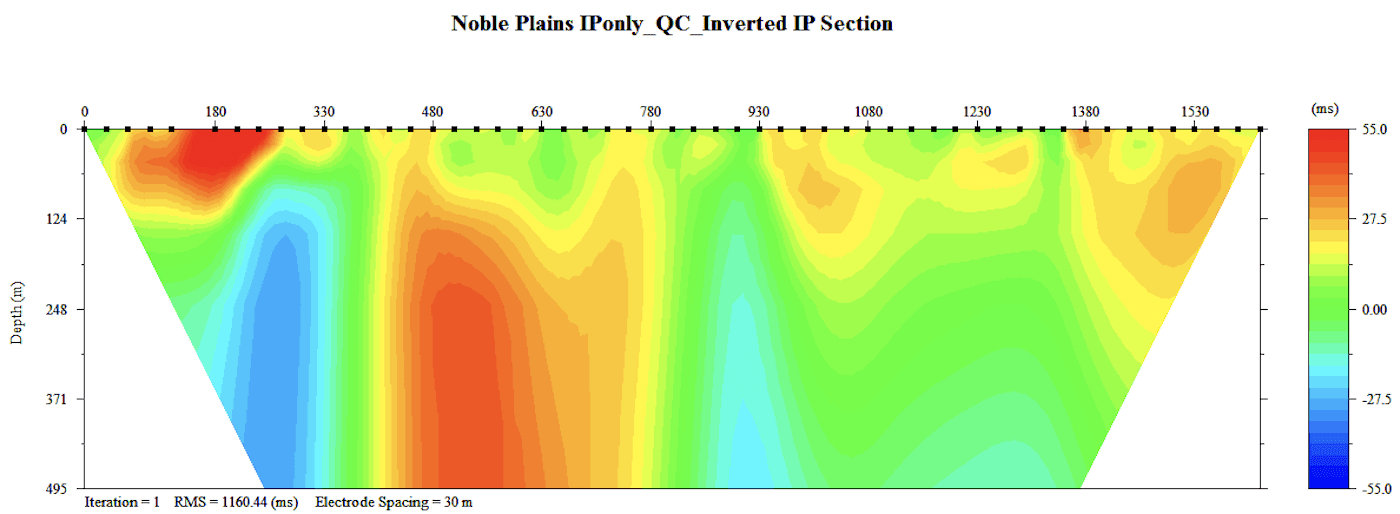
Figure 1: Preliminary induced polarization section, 1,600 m east-west line, Duck Creek Property, Converse County, Wyoming.
Roll-Front Uranium and IP, in Plain Terms
Roll-front uranium deposits, the style of mineralization targeted by in-situ recovery (“ISR”) operations across Wyoming, form where oxygen-bearing groundwater flowing through porous sandstone meets oxygen-poor, or reducing, ground. Uranium travelling in solution drops out of the water at that boundary, known as a redox front, and accumulates in a crescent-shaped body. Finding the deposit is, in large part, a matter of finding that boundary.
Induced polarization measures how the ground holds and releases a small electrical charge, a property that differs between oxidized and reduced sandstone. Mapping that contrasts from surface allows drill holes to be positioned on interpreted targets rather than drilled blind.
"It is worth being clear about what our 6.36-million-pound resource at Duck Creek actually represents," stated Drew Zimmerman, CEO of Noble Plains. "That resource sits on roughly 2.5 miles of a 5.25-mile trend, and every pound of it comes from the shallower of the two formations we consider prospective. Historical open pits further along that same trend tell us the mineralization does not stop where our resource stops. We now have our first target in the deeper Fort Union Formation, the horizon that holds most of the known uranium in this part of the Powder River Basin, including on the neighbouring projects held by Cameco and UEC. The question is how many more pounds are along the trend and in the formation below, and how efficiently we can define them."
A Low-Cost Targeting Tool
The survey gives the Company a low-cost, repeatable tool that could justify running multiple east-west oriented IP lines along the 5.25-mile length of the property to map and model the Fort Union redox front ahead of drill testing. Relative to the cost of a wide-spaced reconnaissance drill program, the geophysical approach is a small fraction of the expenditure, and it is consistent with the data driven approach Noble Plains has advanced its assets to date.
About Noble Plains Uranium
Noble Plains Uranium Corp. is a U.S.-focused uranium exploration and development company advancing a portfolio of high-potential projects amenable to In Situ Recovery (ISR) — the most capital-efficient and environmentally responsible method of uranium extraction. Our strategy targets historically drilled and underexplored assets in proven jurisdictions, with the objective of rapidly delineating NI 43101-compliant resources and building a scalable inventory of domestic uranium.
More information is available at: www.nobleplains.com X: https://x.com/NOBLuranium
On Behalf of the Board of Directors,
“Drew Zimmerman”, President & CEO
For further information, please contact: Drew Zimmerman: (778) 686-0973
Bradley Parkes, P.Geo., VP Exploration of Noble Plains Uranium Corp., is a Qualified Person as defined in National Instrument 43-101 – Standards of Disclosure for Mineral Projects, and has reviewed and approved the scientific and technical information contained in this news release. Mr. Parkes is not independent of the Company.
This news release includes certain forward-looking statements as well as management's objectives, strategies, beliefs and intentions. Forward looking statements are frequently identified by such words as "may", "will", "plan", "expect", "anticipate", "estimate", "intend", "interpreted", "potential" and similar words referring to future events and results. Forward-looking statements include, but are not limited to, statements regarding the interpretation of the geophysical data described in this news release, the presence, geometry and continuity of a redox front in the Fort Union Formation, the potential for uranium mineralization in the Fort Union Formation at Duck Creek, the completion of further data processing and inversion by UWNSG, the planned additional IP survey lines and any resulting drill program, the timing of that work and its results, the potential to outline or expand a uranium resource prepared in accordance with National Instrument 43-101 standards, the potential to confirm or expand mineralization, uranium market conditions and uranium prices, and the expected advancement of the Company's exploration strategy. Forward-looking statements are based on the current opinions and expectations of management. All forward-looking information is inherently uncertain and subject to a variety of assumptions, risks and uncertainties, including but not limited to: the indirect and interpretive nature of geophysical data and the risk that geophysical anomalies do not reflect uranium mineralization, the Company's ability to complete further geophysical surveys and any drill program as planned, the availability of financing, the interpretation of historic data, the accuracy of geological modelling, the results of drilling and downhole probing, operational risks and weather delays, regulatory approvals, availability of equipment and personnel, the speculative nature of mineral exploration and development, and fluctuating commodity prices, as described in more detail in our recent securities filings available at www.sedarplus.ca. Actual events or results may differ materially from those projected in the forward-looking statements and we caution against placing undue reliance thereon. We assume no obligation to revise or update these forward-looking statements except as required by applicable law.
Neither the TSX Venture Exchange nor its Regulations Services Provider (as that term is defined in the policies of the TSX Venture Exchange) accept responsibility for the adequacy or accuracy of this release.
Noble Plains Uranium Geophysical Survey Identifies Deeper Fort Union Target at Duck Creek
News Release
•
Sep 1, 2026
September 1, 2026 – Vancouver, British Columbia – Noble Plains Uranium Corp. (TSXV: NOBL, OTCQB: NBLXF, FSE: INE0) (“Noble Plains” or the “Company”), a U.S.-focused uranium exploration and development company, is pleased to report preliminary results from an induced polarization (“IP”) geophysical survey completed at its flagship Duck Creek Property in Converse County, Wyoming. The survey was conducted by the University of Wyoming Near-Surface Geophysics Instrument Center (“UWNSG”) and was designed to test whether IP could detect both the shallow uranium mineralization already defined in the Wasatch Formation and, more importantly, deeper targets in the underlying Fort Union Formation. Preliminary results indicate it did both.
Highlights
Deeper target identified: A significant IP anomaly extends approximately 380 metres (1,247 feet) along the survey line at a depth of roughly 200 metres (655 feet), interpreted as a potential redox front in the Fort Union Formation.
Method validated on known mineralization: The same survey line independently detected the shallower Wasatch Formation mineralization already defined by drilling, providing confidence that the technique is resolving real geology at Duck Creek.
An untested Formation at Duck Creek: The Fort Union Formation hosts the neighbouring Smith Ranch-Highland and Barge uranium deposits but has not been properly tested on Duck Creek. The Company’s entire existing mineral resource, 5.32 million pounds U₃O₈ Indicated and 1.04 million pounds U₃O₈ Inferred, sits above in the Wasatch Formation.
Independent execution: Survey completed by UWNSG, with further data processing and inversion now underway.
Why the Fort Union Formation Matters
The Duck Creek property is 5.25 miles (8.4 km) long and lies between Cameco’s Smith Ranch-Highland and UEC’s Barge uranium projects, both of which are host mineralization in the Fort Union Formation. Noble Plains’ initial drilling at Duck Creek was deliberately focused on the shallower Wasatch Formation, where it delivered a maiden NI 43-101 mineral resource estimate of 5.32 million pounds U₃O₈ Indicated and 1.04 million pounds U₃O₈ Inferred. The Fort Union Formation beneath that resource has never been properly drill tested on the property. Management has long viewed the Fort Union formation as meaningful additional potential at Duck Creek but has been unwilling to commit large scale drilling capital to a 5.25-mile trend without a way to narrow the targeting. The objective of this survey was to test a cost-effective targeting technique capable of locating mineralized roll-front noses at Fort Union depths. Preliminary results indicate that objective has been met.
Dr. Brad Carr, Director of UWNSG, stated, “In traditional uranium exploration and characterization, radiometric surveys followed by drilling and borehole gamma logging are the standard approaches. Those methods are reliable, but they only tell you what is happening directly at the drill hole. Seismic reflection lets us image the geometry of the sand packages between holes, which is one of the more effective ways to help distinguish sands likely to host mineralization within the Fort Union. Pairing that with induced polarization across the redox front helps trace the boundary between oxidized and reduced conditions, the geochemical setting where roll-front uranium deposits tend to form, over a much larger area than drilling alone could economically cover. Together, these datasets give the Company a more complete subsurface picture to guide both near-term drill targeting and, longer term, extraction planning.”
Preliminary Survey Results
The program consisted of a single 1,600-metre (5,250-foot) east-west oriented IP line. Preliminary results identify a significant IP anomaly (shown in red on Figure 1) between the 400-metre and 780-metre marks along the line at a depth of approximately 200 metres, which is interpreted to represent a potential redox front in the Fort Union Formation. In the known Wasatch Formation, mineralization appears as a separate, shallower response at approximately 950 metres along the line. A near-surface anomaly at the 180-metre mark corresponds to a known gas pipeline. Further processing and inversion of the data is in progress by UWNSG.
Figure 1: Preliminary induced polarization section, 1,600 m east-west line, Duck Creek Property, Converse County, Wyoming.
Roll-Front Uranium and IP, in Plain Terms
Roll-front uranium deposits, the style of mineralization targeted by in-situ recovery (“ISR”) operations across Wyoming, form where oxygen-bearing groundwater flowing through porous sandstone meets oxygen-poor, or reducing, ground. Uranium travelling in solution drops out of the water at that boundary, known as a redox front, and accumulates in a crescent-shaped body. Finding the deposit is, in large part, a matter of finding that boundary.
Induced polarization measures how the ground holds and releases a small electrical charge, a property that differs between oxidized and reduced sandstone. Mapping that contrasts from surface allows drill holes to be positioned on interpreted targets rather than drilled blind.
"It is worth being clear about what our 6.36-million-pound resource at Duck Creek actually represents," stated Drew Zimmerman, CEO of Noble Plains. "That resource sits on roughly 2.5 miles of a 5.25-mile trend, and every pound of it comes from the shallower of the two formations we consider prospective. Historical open pits further along that same trend tell us the mineralization does not stop where our resource stops. We now have our first target in the deeper Fort Union Formation, the horizon that holds most of the known uranium in this part of the Powder River Basin, including on the neighbouring projects held by Cameco and UEC. The question is how many more pounds are along the trend and in the formation below, and how efficiently we can define them."
A Low-Cost Targeting Tool
The survey gives the Company a low-cost, repeatable tool that could justify running multiple east-west oriented IP lines along the 5.25-mile length of the property to map and model the Fort Union redox front ahead of drill testing. Relative to the cost of a wide-spaced reconnaissance drill program, the geophysical approach is a small fraction of the expenditure, and it is consistent with the data driven approach Noble Plains has advanced its assets to date.
About Noble Plains Uranium
Noble Plains Uranium Corp. is a U.S.-focused uranium exploration and development company advancing a portfolio of high-potential projects amenable to In Situ Recovery (ISR) — the most capital-efficient and environmentally responsible method of uranium extraction. Our strategy targets historically drilled and underexplored assets in proven jurisdictions, with the objective of rapidly delineating NI 43101-compliant resources and building a scalable inventory of domestic uranium.
More information is available at: www.nobleplains.com X: https://x.com/NOBLuranium
On Behalf of the Board of Directors,
“Drew Zimmerman”, President & CEO
For further information, please contact: Drew Zimmerman: (778) 686-0973
Bradley Parkes, P.Geo., VP Exploration of Noble Plains Uranium Corp., is a Qualified Person as defined in National Instrument 43-101 – Standards of Disclosure for Mineral Projects, and has reviewed and approved the scientific and technical information contained in this news release. Mr. Parkes is not independent of the Company.
This news release includes certain forward-looking statements as well as management's objectives, strategies, beliefs and intentions. Forward looking statements are frequently identified by such words as "may", "will", "plan", "expect", "anticipate", "estimate", "intend", "interpreted", "potential" and similar words referring to future events and results. Forward-looking statements include, but are not limited to, statements regarding the interpretation of the geophysical data described in this news release, the presence, geometry and continuity of a redox front in the Fort Union Formation, the potential for uranium mineralization in the Fort Union Formation at Duck Creek, the completion of further data processing and inversion by UWNSG, the planned additional IP survey lines and any resulting drill program, the timing of that work and its results, the potential to outline or expand a uranium resource prepared in accordance with National Instrument 43-101 standards, the potential to confirm or expand mineralization, uranium market conditions and uranium prices, and the expected advancement of the Company's exploration strategy. Forward-looking statements are based on the current opinions and expectations of management. All forward-looking information is inherently uncertain and subject to a variety of assumptions, risks and uncertainties, including but not limited to: the indirect and interpretive nature of geophysical data and the risk that geophysical anomalies do not reflect uranium mineralization, the Company's ability to complete further geophysical surveys and any drill program as planned, the availability of financing, the interpretation of historic data, the accuracy of geological modelling, the results of drilling and downhole probing, operational risks and weather delays, regulatory approvals, availability of equipment and personnel, the speculative nature of mineral exploration and development, and fluctuating commodity prices, as described in more detail in our recent securities filings available at www.sedarplus.ca. Actual events or results may differ materially from those projected in the forward-looking statements and we caution against placing undue reliance thereon. We assume no obligation to revise or update these forward-looking statements except as required by applicable law.
Neither the TSX Venture Exchange nor its Regulations Services Provider (as that term is defined in the policies of the TSX Venture Exchange) accept responsibility for the adequacy or accuracy of this release.
Noble Plains Uranium Geophysical Survey Identifies Deeper Fort Union Target at Duck Creek
News Release
•
Sep 1, 2026
September 1, 2026 – Vancouver, British Columbia – Noble Plains Uranium Corp. (TSXV: NOBL, OTCQB: NBLXF, FSE: INE0) (“Noble Plains” or the “Company”), a U.S.-focused uranium exploration and development company, is pleased to report preliminary results from an induced polarization (“IP”) geophysical survey completed at its flagship Duck Creek Property in Converse County, Wyoming. The survey was conducted by the University of Wyoming Near-Surface Geophysics Instrument Center (“UWNSG”) and was designed to test whether IP could detect both the shallow uranium mineralization already defined in the Wasatch Formation and, more importantly, deeper targets in the underlying Fort Union Formation. Preliminary results indicate it did both.
Highlights
Deeper target identified: A significant IP anomaly extends approximately 380 metres (1,247 feet) along the survey line at a depth of roughly 200 metres (655 feet), interpreted as a potential redox front in the Fort Union Formation.
Method validated on known mineralization: The same survey line independently detected the shallower Wasatch Formation mineralization already defined by drilling, providing confidence that the technique is resolving real geology at Duck Creek.
An untested Formation at Duck Creek: The Fort Union Formation hosts the neighbouring Smith Ranch-Highland and Barge uranium deposits but has not been properly tested on Duck Creek. The Company’s entire existing mineral resource, 5.32 million pounds U₃O₈ Indicated and 1.04 million pounds U₃O₈ Inferred, sits above in the Wasatch Formation.
Independent execution: Survey completed by UWNSG, with further data processing and inversion now underway.
Why the Fort Union Formation Matters
The Duck Creek property is 5.25 miles (8.4 km) long and lies between Cameco’s Smith Ranch-Highland and UEC’s Barge uranium projects, both of which are host mineralization in the Fort Union Formation. Noble Plains’ initial drilling at Duck Creek was deliberately focused on the shallower Wasatch Formation, where it delivered a maiden NI 43-101 mineral resource estimate of 5.32 million pounds U₃O₈ Indicated and 1.04 million pounds U₃O₈ Inferred. The Fort Union Formation beneath that resource has never been properly drill tested on the property. Management has long viewed the Fort Union formation as meaningful additional potential at Duck Creek but has been unwilling to commit large scale drilling capital to a 5.25-mile trend without a way to narrow the targeting. The objective of this survey was to test a cost-effective targeting technique capable of locating mineralized roll-front noses at Fort Union depths. Preliminary results indicate that objective has been met.
Dr. Brad Carr, Director of UWNSG, stated, “In traditional uranium exploration and characterization, radiometric surveys followed by drilling and borehole gamma logging are the standard approaches. Those methods are reliable, but they only tell you what is happening directly at the drill hole. Seismic reflection lets us image the geometry of the sand packages between holes, which is one of the more effective ways to help distinguish sands likely to host mineralization within the Fort Union. Pairing that with induced polarization across the redox front helps trace the boundary between oxidized and reduced conditions, the geochemical setting where roll-front uranium deposits tend to form, over a much larger area than drilling alone could economically cover. Together, these datasets give the Company a more complete subsurface picture to guide both near-term drill targeting and, longer term, extraction planning.”
Preliminary Survey Results
The program consisted of a single 1,600-metre (5,250-foot) east-west oriented IP line. Preliminary results identify a significant IP anomaly (shown in red on Figure 1) between the 400-metre and 780-metre marks along the line at a depth of approximately 200 metres, which is interpreted to represent a potential redox front in the Fort Union Formation. In the known Wasatch Formation, mineralization appears as a separate, shallower response at approximately 950 metres along the line. A near-surface anomaly at the 180-metre mark corresponds to a known gas pipeline. Further processing and inversion of the data is in progress by UWNSG.
Figure 1: Preliminary induced polarization section, 1,600 m east-west line, Duck Creek Property, Converse County, Wyoming.
Roll-Front Uranium and IP, in Plain Terms
Roll-front uranium deposits, the style of mineralization targeted by in-situ recovery (“ISR”) operations across Wyoming, form where oxygen-bearing groundwater flowing through porous sandstone meets oxygen-poor, or reducing, ground. Uranium travelling in solution drops out of the water at that boundary, known as a redox front, and accumulates in a crescent-shaped body. Finding the deposit is, in large part, a matter of finding that boundary.
Induced polarization measures how the ground holds and releases a small electrical charge, a property that differs between oxidized and reduced sandstone. Mapping that contrasts from surface allows drill holes to be positioned on interpreted targets rather than drilled blind.
"It is worth being clear about what our 6.36-million-pound resource at Duck Creek actually represents," stated Drew Zimmerman, CEO of Noble Plains. "That resource sits on roughly 2.5 miles of a 5.25-mile trend, and every pound of it comes from the shallower of the two formations we consider prospective. Historical open pits further along that same trend tell us the mineralization does not stop where our resource stops. We now have our first target in the deeper Fort Union Formation, the horizon that holds most of the known uranium in this part of the Powder River Basin, including on the neighbouring projects held by Cameco and UEC. The question is how many more pounds are along the trend and in the formation below, and how efficiently we can define them."
A Low-Cost Targeting Tool
The survey gives the Company a low-cost, repeatable tool that could justify running multiple east-west oriented IP lines along the 5.25-mile length of the property to map and model the Fort Union redox front ahead of drill testing. Relative to the cost of a wide-spaced reconnaissance drill program, the geophysical approach is a small fraction of the expenditure, and it is consistent with the data driven approach Noble Plains has advanced its assets to date.
About Noble Plains Uranium
Noble Plains Uranium Corp. is a U.S.-focused uranium exploration and development company advancing a portfolio of high-potential projects amenable to In Situ Recovery (ISR) — the most capital-efficient and environmentally responsible method of uranium extraction. Our strategy targets historically drilled and underexplored assets in proven jurisdictions, with the objective of rapidly delineating NI 43101-compliant resources and building a scalable inventory of domestic uranium.
More information is available at: www.nobleplains.com X: https://x.com/NOBLuranium
On Behalf of the Board of Directors,
“Drew Zimmerman”, President & CEO
For further information, please contact: Drew Zimmerman: (778) 686-0973
Bradley Parkes, P.Geo., VP Exploration of Noble Plains Uranium Corp., is a Qualified Person as defined in National Instrument 43-101 – Standards of Disclosure for Mineral Projects, and has reviewed and approved the scientific and technical information contained in this news release. Mr. Parkes is not independent of the Company.
This news release includes certain forward-looking statements as well as management's objectives, strategies, beliefs and intentions. Forward looking statements are frequently identified by such words as "may", "will", "plan", "expect", "anticipate", "estimate", "intend", "interpreted", "potential" and similar words referring to future events and results. Forward-looking statements include, but are not limited to, statements regarding the interpretation of the geophysical data described in this news release, the presence, geometry and continuity of a redox front in the Fort Union Formation, the potential for uranium mineralization in the Fort Union Formation at Duck Creek, the completion of further data processing and inversion by UWNSG, the planned additional IP survey lines and any resulting drill program, the timing of that work and its results, the potential to outline or expand a uranium resource prepared in accordance with National Instrument 43-101 standards, the potential to confirm or expand mineralization, uranium market conditions and uranium prices, and the expected advancement of the Company's exploration strategy. Forward-looking statements are based on the current opinions and expectations of management. All forward-looking information is inherently uncertain and subject to a variety of assumptions, risks and uncertainties, including but not limited to: the indirect and interpretive nature of geophysical data and the risk that geophysical anomalies do not reflect uranium mineralization, the Company's ability to complete further geophysical surveys and any drill program as planned, the availability of financing, the interpretation of historic data, the accuracy of geological modelling, the results of drilling and downhole probing, operational risks and weather delays, regulatory approvals, availability of equipment and personnel, the speculative nature of mineral exploration and development, and fluctuating commodity prices, as described in more detail in our recent securities filings available at www.sedarplus.ca. Actual events or results may differ materially from those projected in the forward-looking statements and we caution against placing undue reliance thereon. We assume no obligation to revise or update these forward-looking statements except as required by applicable law.
Neither the TSX Venture Exchange nor its Regulations Services Provider (as that term is defined in the policies of the TSX Venture Exchange) accept responsibility for the adequacy or accuracy of this release.
Other Recent News Releases
The latest updates on project advancement, acquisitions, and corporate milestones.
Noble Plains Uranium Geophysical Survey Identifies Deeper Fort Union Target at Duck Creek
Sep 1, 2026
Is pleased to report preliminary results from an induced polarization (“IP”) geophysical survey completed at its flagship Duck Creek Property in Converse County, Wyoming.
Read Now →
Noble Plains Uranium Intersects Uranium in all Drill Holes at Shirley Central Project, Wyoming
Aug 10, 2026
Announces the results of the recently completed seven-hole confirmation drill program at its Shirley Central Project in Wyoming’s prolific Shirley Basin.
Read Now →
Noble Plains Uranium Commences Confirmation Drill Program at Shirley Central Project
Jul 28, 2026
Announces it has mobilized a drill rig to its Shirley Central Project in Wyoming’s prolific Shirley Basin.
Read Now →

Other Recent News Releases
The latest updates on project advancement, acquisitions, and corporate milestones.
Noble Plains Uranium Geophysical Survey Identifies Deeper Fort Union Target at Duck Creek
Sep 1, 2026
Is pleased to report preliminary results from an induced polarization (“IP”) geophysical survey completed at its flagship Duck Creek Property in Converse County, Wyoming.
Read Now →
Noble Plains Uranium Intersects Uranium in all Drill Holes at Shirley Central Project, Wyoming
Aug 10, 2026
Announces the results of the recently completed seven-hole confirmation drill program at its Shirley Central Project in Wyoming’s prolific Shirley Basin.
Read Now →
Noble Plains Uranium Commences Confirmation Drill Program at Shirley Central Project
Jul 28, 2026
Announces it has mobilized a drill rig to its Shirley Central Project in Wyoming’s prolific Shirley Basin.
Read Now →
Other Recent News Releases
The latest updates on project advancement, acquisitions, and corporate milestones.
Noble Plains Uranium Geophysical Survey Identifies Deeper Fort Union Target at Duck Creek
Sep 1, 2026
Is pleased to report preliminary results from an induced polarization (“IP”) geophysical survey completed at its flagship Duck Creek Property in Converse County, Wyoming.
Read Now →
Noble Plains Uranium Intersects Uranium in all Drill Holes at Shirley Central Project, Wyoming
Aug 10, 2026
Announces the results of the recently completed seven-hole confirmation drill program at its Shirley Central Project in Wyoming’s prolific Shirley Basin.
Read Now →
Noble Plains Uranium Commences Confirmation Drill Program at Shirley Central Project
Jul 28, 2026
Announces it has mobilized a drill rig to its Shirley Central Project in Wyoming’s prolific Shirley Basin.